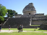
| Yucatan Day 2: Chichen Itza | | | [24-Nov-2024]
Got to Chichen Itza before it opened to avoid the tourist busses. Mexico insists on having 3 pay stations. One for parking, one for the state and one for the federal government making entering any park a pain. They also allow local vendors to come in and set up on the paths of the park but only when the park opens so if you get there when it opened the vendors are all pushing carts to get to their place. Thankfully they have a separate entrance.
Signage and interpretation is lacking. Many ruins have little more than a name and at best a single plaque that is in Spanish, English and Mayan so the info provided is low. Museums with artifacts are also lacking. Almost no directional signs.
Chichen Itza itself is mostly clear of trees and obstructions. You cant climb any of the ruins. They also hide the best carved reliefs way back in the back.
Photos
|
| Sequoia and Kings Canyon | | | [07-Oct-2023]
Planned to go to Death Valley but the roads in the park were closed because it rained. Instead a 4 hour from drive from L.A. across flat nothing to the mountains and Sequoia. Did geocache on the way in, Paul Bunyan.
People all over the Sequoia part, no one in the Kings Canyon part. Blisters on both feet because of the shoes from the day before but still hiked several miles. Then started to get a sore throat because of pine trees. Sequoia altitude is also like 8000ft so cant breathe when walking up hill. All this will be a theme of the rest of the trip; blisters, too high and stuffed up.
Giant trees are cool though. No point in it being two parks. Spent all day there just leaving King's Canyon at sunset. Had to drive though prescribed burns on the way out.
|
| Pawnee Rock | | | [29-Jun-2020]
There is nothing to do in Larned Kansas. Went nearby to Pawnee Rock. |
| Day 2: Mackinac Island | | | [11-Sep-2018]
Took the early ferry to Mackinac Island. Got there before the main fort opened so went walking around the island first doing the uphill part while it was still cool.
Went out to The Arch Rock where there was a geocache and a marker for an old watch tower.
Stopped at the Ft. Holmes a reconstruction of a fort designed to hold the high point of the island, and another geocache.
On the way down stopped at Skull Cave. Not much to see.
Ft. Mackinac was the main reason for being out there. Originally a British fort, handed over to the Americans, retaken by the British in the war of 1812, then given back at the end it sits on the bluff overlooking the town.
Went to the Butterfly Museum and walked around the island before leaving.
Destroyed another pair of shoes in the 10 miles or so walking around the island.
Finished the day at Michilimackinac the old French settlement/fort.
|
| Day 1: Peshtigo and Feyette | | | [10-Sep-2018]
Had a problem getting a hotel last night. Had to drive 15 miles south to get out of the range of the Packers game. Picked up Craig at 8am.
Stopped at Peshtigo. There was a forest fire the same day as the Chicago fire and destroyed the town and surrounding area. Killed over a thousand people but its lost in history since the other fire happened the same day.
Second stop was Fayette Historic Townsite. This was an old iron smelting site and accompanying village.
Drove on to Mackinaw City, crossing the Mackinaw Bridge. |
| Day 6: Virginia Forts | | | [10-Jul-2014]
Started out first thing at Ft. Norfolk. Its currently on an active army base used by the Corps of Engineers so was not allowed to take pictures towards the modern building. Found a geocache on the property unexpectedly. Its supposed to be a multistage cache that was currently inactive but the final cache was there. Logged it.
Crossed over to Ft. Monroe and took some pictures of Ft. Wool on the way. Last time I was at Ft. Monroe it was an active base, now its a National Park and much better since you dont feel like your being watched and picture taking is allowed. There are still a lot of army signs up about things you shouldnt do however. Old Point Comfort Lighthouse is just outside Ft. Monroe.
Finished the day at Yorktown. There was a lot more there than I expected. Did 2 geocaches ad walked all over the town and inner works, then did the driving tour out to the surrender field and other sites. Did everything for a 3rd geocache down on the beach that was virtual but didnt log it. |
| Day 5: Roanoke, Kitty Hawk | | | [09-Jul-2014]
I think the fort at Roanoke (Ft. Raleigh) is wrong. Its just too small to be the fort for a colony. It compares to some of the redoubts at Yorktown to comparative structures like the fort at Jamestown. The archeologists may have found something, they need to go back and look more. Spent more time at the Gardens than the fort.
Next stop was Kitty Hawk. There is a big monument on the hill. Its not the important thing to see. The first flight took place in the field by the visitor center. There is a smaller rock and then 4 even small markers to mark where the first flights landed. Geocache at the rock.
Drove to Norfolk for the USS Wisconsin. You have to go through the whole several floors of the Nauticus museum and the Hampton Roads Naval Museum to get to it. The ship itself seems bigger than the North Carolina but not as much is open yet. Leaving the Wisconsin tried to take a boat tour of the harbor but it got canceled at the last minute because of weather. The sky opened up 40+ mph winds blowing rain and hail in apocalyptic craziness for half and hour, then drizzle. |
| Day 4: The Outer Banks | | | [08-Jul-2014]
Took the ferry over to Ocracoke in the morning. Did not need reservations. Ocracoke is more of a place than Cedar Island it has hotels, restaurants and such. Went to the Ocracoke Lighthouse, did a geocache at the cemetery and attempted another near the sign Ft. Ocracoke. Ate breakfast, drove up the island and stopped to see the ponies.
At the other end of the island took another ferry across to Hatteras. Did a geocache on the ferry. The ferry takes a crazy route because of sand banks. We did a 180 around the buoy in question.
Graveyard of the Atlantic museum was unimpressive, no photos. Got lucky and there was a lecture by a local on Hatteras part in the Civil War including the battles at Ft. Clark and Ft. Hatteras. Another geocache in the parking lot.
Drove further north. Stopped at the Cape Hatteras Lighthouse but they were not letting people on the balcony so didnt climb it. Next stop was the Bodie Island Lighthouse. Climbed it but couldnt go out on the balcony either.
Ended the day watching the Lost Colony Play at Roanoke. Im seen worse but thats only because I saw that Custer Reenactment out west. Potatoes come from South America not Virginia.
|
| Script fix | | | [08-Jul-2014]
Fixed some of the backend scripts I use. All the cache sites after the Mt. rushmore one should link back to geocahing.com properly now. Will be more work to fix the others. New ones will take more manual entry but will be correct now rather than without names. |
| Day 3 | | | [07-Jul-2014]
Vacation entry is going slowly. Ended day 2 in Southport N.C. needed to take a ferry first thing in the morning. Almost didn't get a hotel in the area. Tried 2 places before finding on with a room. Also destroyed my hiking boots. They have been around for maybe 15 years so its not a surprise. Had to find new ones.
On the way to the ferry came across Ft. Johnson. Only the officers quarters remained. Took some photos of light houses in the distance (Old Baldy, Oak Island). Took the ferry over to Ft. Fisher. Passed the Ft. Fisher Aquarium and then came back to it after the fort. Then did the battery down the road.
Drove on to the USS North Carolina an then Ft. Macon. Did a cache at the fort. Then another drive to the Cedar Island Ferry Terminal.
The terminal is nowhere. Its and hour drive from Morehead City though nothing. The last half hour is in wildlife refuge that is all marsh. You pass some houses at the end, a little store that claims to be the last stop before a 2.5hr ferry (with wifi) and a mile later the landing. There is an abandoned hotel near the landing. No where to stay. Went back to the store. They claim the hotel is open but you have to call. Went back there, there is a number but no service. None (and no wifi) at the store. Driving backwards found a hotel at Sea Level. They had closed. Saw people in the restaurant and they gave me a room ringing it up on the restaurant cash register. Left the key on the dresser as instructed. It was a nice room.
|
| Days 1 and 2 | | | [30-Jun-2014]
Day 1: Jun 15
After leaving Jax went to Ft. Frederica. I think I was there a long time ago, before there was visitor center. Started to look for a geocache but it required wading a creek and just didnt want to do that.
Didnt plan on stopping but needed gas and it was only 3 miles from the exit I got off on so went to Ft. King George.
Drive to SC and got to Ft. Moultrie with an hour to go before they closed. This was long enough to do the inside of the fort. The Endicott bunkers are all visible after 5pm and drove around Sullivans island. What I thought was a WWII observation tower turned out to be the Charleston Light at Sullivans Island after some research. Missed some batteries on the island since there was no map. Did a geocache outside the fort at Osceolas grave.
Went back across the harbor for Ft. Johnson. Stopped at Battery Cheves for a cache but the phone is unreliable and under tree cover just had me running around in circles. Walked around the Charleston Battery Park downtown. The back across the harbor again to stay outside Patriots Point.
Day 2: Jun 16
Did the USS Laffey and Clagmore at Patriots Point before the ferry to Ft. Sumter. Ended up giving mini tours and answering questions for people at the fort. Took some pictures of Castle Pickney on the ferry to and from. Visited the USS Yorktown after coming back to Patriots Point. Somewhere in all this destroyed my hiking boots.
Drove north to attempt Ft. Caswell. Stopped at the Oak Island Lighthouse but it was closed. Withing sight did a geocache at just outside the Coast guard station. Talked to the guy at Ft. Caswell, the baptists who own it are having summer camp and no visitors except on weekends for the summer. Drove on to Southport, NC. Found a Walmart and new hiking boots. Had problems getting a room 2 hotels were full.
|
| Olustee on Saturday | | [18-Feb-2013]
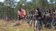
Took Gibson to Olustee Saturday for the reenactment. It was cold and rainy but cleared up half and hour before the battle so there wasnt a crowd but we also didnt have to sit in the rain and wind. Reenactment (or demo since the north won) started out badly. They started 15 minutes early, in the woods on the far side of the field where no one could even make out a solider. They stayed out there for a good 15 minutes, even shooting off cannon in the woods. With the high grass you could only see the smoke from the cannons. Eventually the came into the field and they did a very good job of moving back and forth, flanking and bringing cavalry in close.
We also did several geocaches to and from the reenactment, mostly one I had done before. |
| My mom says I dont post anyore | | | [03-Dec-2012]
This weekend got the strawberries planted. Started laying out the wall of the pond till I ran out of sand. Put in the first to posts of the shed I'm building to store extra hive equipment. Made hot pepper sauce.
The fog was back this morning. It was patchy but very heavy in some places. Near my house it wasnt bad but you couldnt see across the pasture. Near the capital it was as thick as it gets but 6th Ave was completely clear.
Someone found one of my travel bugs that been missing for almost a year. Didnt bother to say where, jsut that they discovered it. |
| A short drive to Mississippi | | | [15-Jul-2012]
Drove to MS (well LA for the forts) to pick up Gibson and Miles. Took a short side trip to Ft. Pike with a stop to take photos of the outside of Ft. Macomb. Id been to both sometime back in college but cant find any pictures. Didnt remember the Ft. Pike was the first of the 3rd system. Its condition isnt really good, wall are crumbling and splitting, Support beams have been added in all the bastions. The museum in the citadel got wiped out by Katrina. Picture will be under the forts site one I upload them.
Did a geocache at the fort an other at the rest area where we picked up the kids. The one at the rest are was literally tied to the tree hanging from a branch about ft up.
We left at 6am and because of traffic in Mobile (stopped for 45min before the tunnel) didnt get back till 10:30.
|
| More Geocaches | | | [08-Jul-2012]
Melissa is looking to take Gibson geocaching and couldnt find one. We found it after dinner, the I did the none closest to their house (it needs work) and the one at the dump I still havent done. Looked for the other one there but between mosquitoes and dark didnt find it. Will look tomorrow in the light, 2 recent people said the couldnt find it but the last person did find it.
|
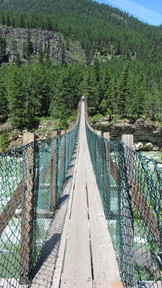
| Day 8: Koontenai Falls and Bridge | | [28-Jun-2012]
Most of the day was driving across what was left of Montana and the Idaho into Washington. Stopped at Koontenai Falls for the falls and a pedestrian suspension bridge. Found an unexpected cache there since there was cell service. GC2V8ZV: Wheeling Around - Kootenai Falls Rest Earthcache. Stopped at a planned cache GC8AB1: 10,000 years ago in the North West after lunch. Ended the day in Spokane and flew out the next morning after just over 2000 miles of driving.
|
| Day 6: Lake Mcdonald Lodge and Avalance | | | [26-Jun-2012]
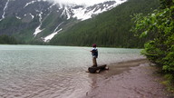
Got the hotel in Apgar and left room reading while I went back out in the drizzling rain. Went back up the length of Lake McDonald to the Lodge and did a geocache: GC9859: Old McDonald had a Lake. Went further back up toward Logan pass and started on the Trail of the Ceders which let to the Avalanche Lake trail, a two mile hike to a glacier lake and then back. The trail was clearly flooded in places and had to be redone. The lake was rather disappointing. It looks much better in pictures. Then there were the crazy people up there fishing in the rain. Saw a bear crossing the Avalanche Creek bridge on the way back but the camera was dying so no good photo.
|
| Day 6: Glacier: Going-to-the-sun road | | | [26-Jun-2012]
Got woken up at 6am by hail. Thought about getting up and hiking to iceberg lake. Went to the hotel lobby to check on the weather first. Couldnt get it because the internet was down. Got drenched on the way back to the room.
Most the day was driving Going-to-the-Sun Road over Logan pass. Its was overcast all day once over the pass rained and hailed some more. Going up wasnt bad and we spent about an hour at the top of the pass. The weather going down was miserable and we really didnt stop to take photos.
There was a little snow on top the pass
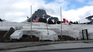
|
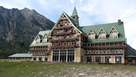
| Day 5: Waterton, Alberta | | [25-Jun-2012]
Spent the afternoon driving up to and visting Waterton Park in Alberta. I think it was nicer than Glacier, more wildlife, even in the little village. It had a little village you could actually get food and cell phone service. Saw a moose on the way, ducks, deer in the town, a fox, mom saw a red fox. Cameron falls and did 2 geocaches in the town.
|
| Day 3: Driving | | | [23-Jun-2012]
Most of day 3 way driving from South Dakota, across Wyoming into Montana to stay at Billings. We did stop at a rest area do do a geocache but I didnt go into the high grass by the river to look for it. I was wearing shorts and it looked to likely there were snakes in there. We did stop for a cache at the Fetterman Massacre Monument right at sunset. Really pretty place, the monument sits up high and looks down on a river valley. Lots of birds, bees and wildflowers. Cows could be heard mooing down in the valley. |
|
|